Among the many puzzles that Stonehenge poses to archaeologists and geologists, none has grown more intriguing in recent years than the origin of its Altar Stone. A new study published in the Journal of Quaternary Science — by Anthony J. I. Clarke, Remy L. J. Veness, Christopher L. Kirkland, and colleagues — brings together detrital zircon analysis and ice-sheet modelling to narrow down where this extraordinary megalith came from, and to ask whether glaciers, not only human hands, may have helped move it south.
Three Stones, Three Origins
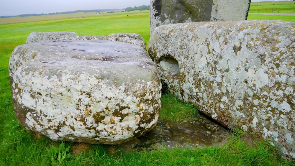
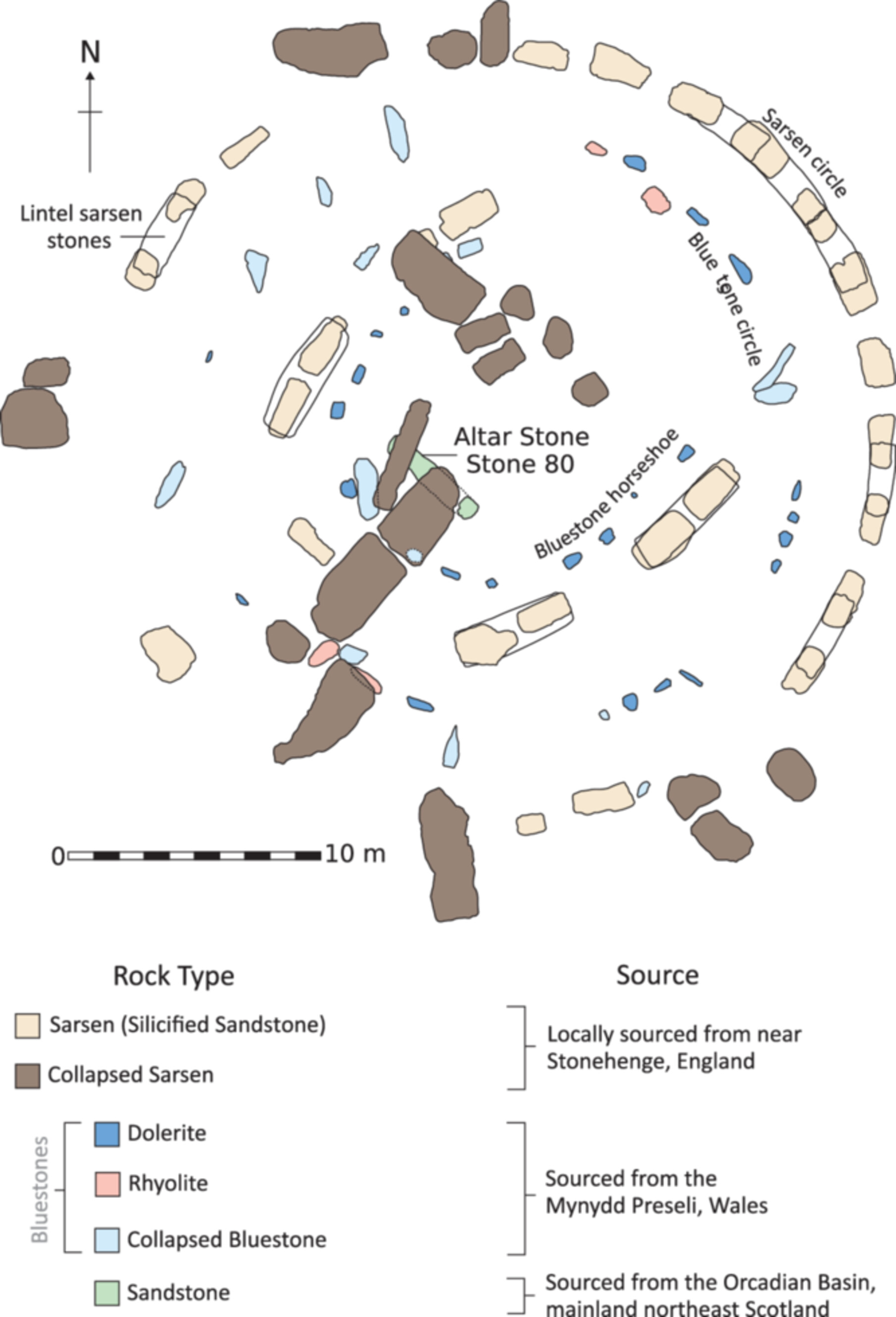
Stonehenge is built from three distinct categories of material. The great sarsen uprights and lintels — the ones that define the monument’s silhouette — come from West Woods, Wiltshire, some 25 kilometres away. The bluestones of the inner circle, encompassing several rock types including dolerite, rhyolite, and tuff, originate from the Mynydd Preseli hills in west Wales, roughly 230 kilometres distant. And then there is the Altar Stone: a single recumbent slab of Devonian Old Red Sandstone, six tonnes in weight, measuring nearly five metres in length — and almost certainly Scottish.
A 2024 study by Clarke and colleagues first proposed a provenance within the Orcadian Basin of northeast Scotland, some 700 kilometres north of Salisbury Plain. The new research sets out to refine that identification and then to ask a question that had previously seemed implausible: could the Late Devensian ice sheet, which covered much of Britain between roughly 29,000 and 12,000 years ago, have moved the stone part of the way?
Zircons from Caithness
The primary tool for provenance work in this study is detrital zircon U-Pb geochronology. Zircon crystals within a sandstone preserve a radiometric age signature that reflects the geology of whatever highlands shed sediment into the ancient basin where they were deposited. By comparing the statistical distribution of zircon ages in the Altar Stone with those from Old Red Sandstone outcrops across Scotland, the researchers can assess geological kinship.
The results are striking in their specificity. Of the five Orcadian Basin outcrop datasets available for comparison, the sandstones at Sarclet — on the Caithness coast — show the closest match to the Altar Stone (a Kolmogorov-Smirnov p-value of 0.96, meaning the two distributions are statistically indistinguishable). Samples from Braemore, Kirtomy, and Portskerra, all from the northern mainland expression of the basin, are also consistent with the Altar Stone’s zircon cargo. Southern outliers — at Rhynie, Aberdeen, and Tomintoul — are excluded: their zircon spectra carry the imprint of different geological terranes and do not match.
The picture that emerges points toward mainland northeast Scotland, and most specifically toward the Caithness and Inverness–Black Isle regions, as the likely source of the Altar Stone.
Can Ice Do the Work?
With a probable source area identified, the study turns to its most speculative question: could the Late Devensian ice sheet have transported the stone southward, at least partway, before Neolithic people completed the journey?
The intuitive answer had long been: probably not. Ice-flow reconstructions of the British-Irish Ice Sheet show that the Orcadian Basin sat near the main north-south drainage divide, and that dominant flow directions from Caithness ran to the north and east — not south toward England. But ice sheets are not static. Over thousands of years, as the ice builds up and retreats in phases, flow vectors shift. A boulder entrained in one phase may travel in a very different direction during a subsequent one.
To capture this complexity, the researchers used a new glacial erratic transport modelling tool applied to the BRITICE-CHRONO ice sheet simulation — a physically calibrated reconstruction of the British-Irish Ice Sheet at 1,000-year time steps. Rather than reading off a single flow vector, the model traces where erratics from a given source area could have come to rest, accounting for the full time-integrated history of shifting ice geometries.
The Dogger Bank Scenario
The modelling results are revealing. For the Caithness source region, the primary dispersal footprint runs to the north and east — consistent with the general flow pattern. But a second experiment, in which source rocks are placed slightly into the Moray Firth (simulating an earlier phase of southward transport that then feeds into later ice flow geometries), produces a more southerly dispersal pathway. In this scenario, erratics from Caithness could have been carried southeast as far as Dogger Bank, the shallow submarine ridge in the southern North Sea.
This is not a trivial finding. Dogger Bank is recognised as the remnant of a Late Devensian end moraine — a landform deposited at the margin of retreating ice — and it was dry land during the low sea levels of the last glacial maximum. Geotechnical surveys from offshore wind farm development have identified sandstone cobbles in the moraine deposits, though detailed provenance data for larger boulders remains sparse, largely because industrial site investigation focuses on engineering hazard rather than geological characterisation.
A large Old Red Sandstone boulder on Dogger Bank — transported glacially from Caithness, perhaps 450 kilometres to the south of its origin — would still lie some 400 kilometres northeast of Stonehenge. But that distance, the authors note, is considerably easier than 700 kilometres from the Scottish mainland, and it involves more sheltered coastal waterways and lower topographic obstacles.
The Temporal Problem
Here the scenario encounters a severe constraint. Dogger Bank was inundated by post-glacial sea-level rise beginning around 8,000 to 7,000 years ago. The Altar Stone, by contrast, was almost certainly erected at Stonehenge around 2,500 BCE — roughly 4,500 years ago. The gap is not minor. If the stone was deposited on Dogger Bank by retreating ice, it would have needed to be retrieved by people before the sea swallowed the landscape — and then stored, or transported to an intermediate location, for approximately three millennia before reaching Salisbury Plain.
The authors do not dismiss the possibility outright — prehistoric communities may well have attributed profound cultural significance to a massive sandstone erratic rising from a landscape undergoing marine transgression — but they are candid about the difficulty. Invoking Dogger Bank as an intermediate stage requires not one extraordinary act of transport, but a multi-phase sequence spanning thousands of years and involving a degree of institutional or cultural continuity that strains credibility.
A separate line of evidence compounds the scepticism. A companion study by Clarke and Kirkland found no detrital mineral signature in river sediments from the Salisbury Plain area that would be expected if glacial processes had delivered Scottish material directly to southern England. The landscape itself does not appear to record a glacial pathway from the north.
What This Leaves Us With
The study’s conclusions are careful to distinguish between what the modelling can establish and what it cannot. It is plausible that Late Devensian ice transported material from the Caithness region to Dogger Bank. It is not possible, on current evidence, to show that the Altar Stone specifically was among that material. And even under the most favourable glacial scenario, substantial human transport would have been required — either from Dogger Bank across 400 kilometres of sea and land, or directly from northeast Scotland across 700 kilometres.
Either way, the Altar Stone’s arrival at Stonehenge implies a society capable of sustained long-distance logistics: the organisation of labour, the maintenance of social networks across enormous geographic distances, and the technological means to move multi-tonne megaliths by sea or over land. This is not a society for which one feels comfortable invoking the word primitive. Isotopic studies of human remains at Stonehenge show individuals who spent their childhoods in Scotland and Wales. A Lewisian gneiss mace head of Scottish origin has been found at the site. Shared rock art motifs link monuments across Britain. The Altar Stone, wherever its precise journey began, is evidence of a world more thoroughly connected than the distances involved might suggest.
Further Work
The researchers identify a clear path for future investigation. Published detrital zircon data for the Orcadian Basin currently covers only mainland outcrops; the Orkney islands, already excluded on geochemical grounds by a separate study, cannot yet be fully assessed using zircon methods. More critically, no high-resolution numerical ice-flow simulation exists for the earlier Anglian glaciation (approximately 450,000 years ago), whose southern extent reached considerably further into England than the Late Devensian ice. Whether Anglian glaciation could have provided a more direct southward transport pathway — entirely bypassing the Dogger Bank temporal problem — remains an open question that better computational models may eventually address.
For now, the Caithness coast stands as the most probable homeland of Stonehenge’s most enigmatic stone. How it travelled from there to Salisbury Plain — whether by human hands alone, or with an assist from ice — remains one of British prehistory’s most stubbornly compelling mysteries.
Source: Anthony J. I. Clarke et al., “From Highlands to Henge: Refining the Provenance and Transport Pathways of Stonehenge’s Altar Stone,” Journal of Quaternary Science (June 2026). https://doi.org/10.1002/jqs.70080